Umm Al Quwain is one of the seven emirates of the United Arab Emirates. Located on the country's northern Arabian Gulf coast, it combines a small urban centre with mangrove-lined waterways, offshore islands, desert landscapes and inland agricultural areas.
It is the second-smallest emirate in the UAE by land area and the least populated, giving it a noticeably different character from the country's larger urban centres.
Umm Al Quwain City is the emirate's capital and main commercial centre, but the wider emirate extends well beyond the city. It includes coastal wetlands and islands, archaeological landscapes, desert settlements and the inland oasis town of Falaj Al Mualla.
The emirate also has a long relationship with the sea.
Fishing, pearling and maritime trade supported communities for generations, while archaeological discoveries show that people were living and trading in this part of the Gulf thousands of years before the formation of the modern UAE.
Today, Umm Al Quwain retains much of that connection with its coast while developing newer industries, infrastructure and a growing blue economy.
| Fact | Details |
|---|---|
| Emirate | Umm Al Quwain |
| Country | United Arab Emirates |
| Capital | Umm Al Quwain City |
| Area | Approximately 720 sq km |
| Major inland area | Falaj Al Mualla |
| Official language | Arabic |
| Currency | UAE Dirham (AED) |
| Time zone | UTC +4 |
| Climate | Hot desert climate |
| Coast | Arabian Gulf |
| Known for | Mangroves, islands, fishing, archaeology and coastal heritage |
Umm Al Quwain is both an emirate and the name commonly used for its capital city.
The Emirate of Umm Al Quwain is one of the seven emirates that form the UAE.
Umm Al Quwain City is its capital and principal urban centre.
This distinction matters because the emirate includes much more than the city itself.
Coastal islands and mangroves extend around its lagoon environment, while the territory reaches inland towards desert communities and Falaj Al Mualla.
For this reason, understanding Umm Al Quwain means looking at the entire emirate rather than treating the capital city as its only important area.
Umm Al Quwain lies in the northern part of the United Arab Emirates along the Arabian Gulf.
Its territory covers approximately 720 square kilometres, making it the country's second-smallest emirate after Ajman.
Sharjah lies to the southwest, while Ras Al Khaimah is located to the northeast.
The geography changes noticeably between the coast and interior.
Near the sea, shallow waterways, tidal areas, islands and mangrove habitats create a landscape shaped by water.
Further inland, the environment becomes increasingly dry, with desert terrain eventually reaching agricultural areas around Falaj Al Mualla.
This combination of coast, wetland, desert and oasis-influenced agriculture gives a relatively small emirate considerable geographical variety.
Umm Al Quwain City developed along a narrow coastal peninsula beside Khor Al Bidiyah.
Its location provided access to sheltered waters, fishing grounds and maritime routes, making the sea central to the settlement's development.
The older part of the city grew around the fort, harbour and traditional neighbourhoods.
Modern development has expanded beyond that historic core, but the city remains much smaller and less densely built than Dubai, Abu Dhabi or Sharjah.
This scale is part of its character.
Instead of a continuous high-rise skyline, Umm Al Quwain contains lower-density residential areas, government buildings, commercial districts, waterfront spaces and industrial zones.
The lagoon and surrounding islands remain visually and environmentally important to the city.
The wider emirate is not entirely coastal.
Around Falaj Al Mualla, the landscape reflects a different relationship with water and settlement.
Located inland from Umm Al Quwain City, Falaj Al Mualla historically developed where groundwater supported agriculture.
The name itself points towards the importance of the falaj, a traditional system used to move and distribute water.
Agriculture became possible around these water resources, supporting date palms and other farming activities.
Today, the area remains associated with agriculture, including farms, poultry and dairy activity.
Falaj Al Mualla therefore provides an important contrast with the maritime history of Umm Al Quwain City.
One developed around the sea.
The other depended more heavily on access to inland water and agricultural land.
Together, they show why the history of the emirate cannot be explained entirely through its coastline.
Human activity in the area now known as Umm Al Quwain reaches back thousands of years.
Archaeological discoveries across the emirate have revealed settlements, pottery, tombs and other material from different periods of Arabian history.
Some finds indicate human communities in the region as early as the sixth millennium BC.
This long archaeological record matters because it places Umm Al Quwain within a much wider story of settlement around the Arabian Gulf.
Communities here were not completely isolated.
Coastal access allowed people to fish, travel and participate in trading networks connecting different parts of Arabia with regions farther across the Gulf and Indian Ocean.
Several archaeological sites help reconstruct that history.
Among the most important is Ed-Dur.
Ed-Dur was a significant settlement in Umm Al Quwain around two thousand years ago.
Archaeological work has uncovered stone buildings, graves, pottery, glassware and other objects that provide evidence of an organised community with connections beyond the immediate region.
Imported materials are particularly important.
They indicate that people living at Ed-Dur participated in broader commercial networks rather than depending entirely on local resources.
The site's position near the Gulf would have made maritime connections possible.
Ed-Dur therefore helps show that the northern Emirates were part of active regional exchange networks long before oil, modern ports or the establishment of the UAE.
Rather than presenting ancient Umm Al Quwain as an isolated desert settlement, the archaeology points towards communities connected by both land and sea.
Another important archaeological area associated with the region is Tell Abraq, located near the modern boundary between Umm Al Quwain and Sharjah.
The site contains evidence from multiple periods, including Bronze and Iron Age occupation.
Its long sequence of settlement helps archaeologists understand how communities in southeastern Arabia changed over time.
Together with Ed-Dur and other discoveries in Umm Al Quwain, Tell Abraq demonstrates that the region supported human communities for thousands of years.
Changes in architecture, burial practices, pottery and trade goods reveal how those communities adapted to different economic and environmental conditions.
This archaeological depth is one of the emirate's strongest but sometimes overlooked characteristics.
The modern political history of Umm Al Quwain is associated with the Al Mualla ruling family.
The ruling lineage developed from the Al Ali tribe, whose communities were connected with the coast and islands around Umm Al Quwain.
Water availability played an important role in settlement patterns.
As communities established themselves around the mainland coastal area, the settlement that became Umm Al Quwain City grew in political and economic importance.
A fort was established in the eighteenth century and became associated with the ruling family and administration of the emirate.
The old fort remains one of the clearest physical links between the historic settlement and modern Umm Al Quwain.
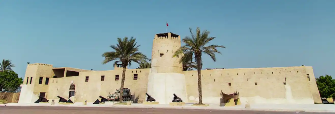
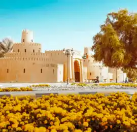
Umm Al Quwain Fort was built in the eighteenth century and became a centre of government and residence for the ruling family.
Its defensive walls and towers reflected the practical needs of a coastal settlement during a period when local communities needed to protect people, resources and access routes.
As the city changed, the role of the fort changed with it.
The restored building now functions as a museum, preserving archaeological objects, historic material and displays connected with the emirate's past.
The fort is valuable because it connects several layers of Umm Al Quwain's history.
It represents local government and defence, while the museum collections help visitors understand much older archaeological periods that existed long before the fort itself.
During the twentieth century, the Trucial States experienced major political and economic changes.
When Britain prepared to end its treaty relationships in the Gulf, discussions began over creating a federation between the emirates.
Umm Al Quwain joined Abu Dhabi, Dubai, Sharjah, Ajman and Fujairah in establishing the United Arab Emirates on 2 December 1971.
Ras Al Khaimah joined the federation the following year.
Since then, Umm Al Quwain has continued to maintain its own local government and ruling family while operating as part of the UAE's federal system.
Its smaller population and territory have not prevented it from maintaining a distinct identity within the federation.
The Arabian Gulf shaped life in Umm Al Quwain long before modern development.
Fishing provided food and income, while boats connected coastal settlements with neighbouring communities.
The shallow waters, creeks and islands around the emirate supported a productive marine environment.
Fishing remains economically and culturally important today.
This continuity is significant.
In some Gulf cities, modern urban development has made the connection with older maritime livelihoods harder to see.
In Umm Al Quwain, the relationship with fishing and the coast remains much more visible.
Fishing boats, waterfront activity and seafood businesses continue to form part of everyday economic life.
Pearling was another important part of the traditional Gulf economy.
Before oil transformed the region, natural pearls collected from Gulf waters were traded through networks reaching international markets.
Pearling required specialised knowledge.
Divers, boat crews and merchants all formed part of an industry shaped by the seasons and conditions at sea.
The decline of natural Gulf pearling during the twentieth century affected communities throughout the region as cultured pearls and changing global markets reduced demand.
Umm Al Quwain gradually moved towards other forms of economic activity, but its maritime history remains central to understanding how communities supported themselves before modern industries developed.
One of Umm Al Quwain's most distinctive natural features is its mangrove environment.
Mangroves grow in shallow coastal waters where land and sea meet.
Their root systems create protected habitats for juvenile fish and other marine life, while the surrounding wetlands provide feeding and resting areas for birds.
These environments also help stabilise parts of the coastline.
Around Umm Al Quwain, mangroves, tidal channels and islands form a landscape very different from the open sandy beaches often associated with the UAE.
The water can be shallow and calm, with narrow channels passing between vegetation and exposed tidal areas.
This environment is both ecologically valuable and an important part of the emirate's visual identity.
A series of islands lies off the coast of Umm Al Quwain.
Among the best known is Al Siniya Island, which sits close to Umm Al Quwain City.
The island and surrounding coastal environment support wildlife and provide habitat for birds and other species.
Gazelles have also been associated with the island, while the surrounding marine environment supports fish and turtles.
These islands are not simply recreational spaces.
They form part of the ecological system surrounding the lagoon and preserve landscapes that have become less common around heavily urbanised parts of the Gulf.
Their proximity to the city creates one of Umm Al Quwain's most interesting contrasts: an inhabited coastal centre sitting immediately beside relatively undeveloped natural environments.
Umm Al Quwain's mixture of mangroves, tidal flats, islands, open Gulf waters and desert supports a range of wildlife.
Coastal habitats attract resident and migratory birds.
Shallow waters provide feeding and nursery environments for marine species.
Turtles can be found in the wider marine environment, while fish populations have supported local fishing communities for generations.
On land, desert and island habitats support species adapted to hot, dry conditions.
The emirate's natural value comes partly from the fact that large areas remain less intensely developed than the urban coastlines of some neighbouring emirates.
Protecting these habitats is therefore important not only for wildlife but also for maintaining the environmental character that distinguishes Umm Al Quwain.
Umm Al Quwain's economy reflects both its traditional industries and its modern development.
Fishing and seafood remain important because of the emirate's long coastline and maritime heritage.
Agriculture contributes more strongly in inland areas such as Falaj Al Mualla.
Manufacturing, logistics, construction, trade and small businesses have expanded alongside these older activities.
The Ahmed Bin Rashid Port supports maritime trade and industrial activity, while the Umm Al Quwain Free Trade Zone provides a base for businesses operating across different sectors.
Tourism also contributes through coastal recreation, heritage sites and leisure facilities.
The economic structure is therefore more varied than the emirate's small size might suggest.
The sea is also part of Umm Al Quwain's future economic planning.
The emirate has developed a Sustainable Blue Economy Strategy 2031, connecting economic development with the long-term use and protection of marine and coastal resources.
A blue economy can include activities such as fisheries, marine industries, tourism, coastal development and environmental conservation.
For Umm Al Quwain, this approach is particularly relevant.
Mangroves, islands, fisheries and coastal waters are not separate from the local economy. They are among the natural resources on which parts of that economy depend.
Balancing economic activity with environmental protection will therefore influence how the emirate develops in the coming years.
Umm Al Quwain's culture reflects generations of life between sea, desert and inland agricultural areas.
Along the coast, fishing, pearling and boat building influenced working life.
Inland, farming and livestock became more important where water was available.
Family and tribal relationships formed the social structure connecting these communities.
Traditional Emirati hospitality remains part of this cultural identity.
Arabic coffee and dates are closely associated with welcoming guests, while social gatherings continue to place importance on family and community relationships.
Traditional architecture also responded to the local environment.
Buildings were designed around shade, airflow and materials available in the region.
Although modern construction has transformed the city, forts, older neighbourhoods and heritage sites still preserve elements of this earlier built environment.
Travel away from the coast and Umm Al Quwain's landscape gradually becomes drier.
Mangroves and tidal water give way to open desert, dunes and inland settlements.
Historically, desert areas connected coastal communities with grazing land, farms and routes leading towards other parts of the Emirates.
Today the desert also supports recreation and tourism.
Organised activities may include dune driving, camel experiences, camping and other outdoor excursions.
However, desert tourism is only one modern use of this landscape.
For generations, local communities understood the desert in practical terms as a place of movement, livestock, resources and connections between settlements.
Detailed safari packages belong on dedicated commercial pages rather than this general guide to Umm Al Quwain.
Umm Al Quwain has a hot desert climate influenced by its coastal location.
Summers are extremely hot, and humidity from the Arabian Gulf can make conditions feel particularly intense.
Winters are much milder.
The cooler months are generally more comfortable for exploring heritage areas, mangroves, waterfront locations and desert landscapes.
Rainfall is limited and irregular, as it is across much of the UAE.
Visitors planning outdoor activities should consider both heat and humidity rather than looking only at air temperature.
Early mornings and evenings are generally more comfortable during warmer parts of the year.
Umm Al Quwain is connected to the other northern emirates and Dubai through the UAE's road network.
Driving is one of the easiest ways to reach and explore the emirate.
Travel time depends heavily on the starting point and traffic conditions, particularly when approaching from Dubai or Sharjah during busy periods.
Within Umm Al Quwain City, taxis and private vehicles are commonly used.
A vehicle becomes more useful when travelling beyond the city towards inland areas such as Falaj Al Mualla or exploring different parts of the wider emirate.
Because attractions and natural areas are spread out, visitors should not assume the entire emirate can be explored conveniently on foot.
Umm Al Quwain is best understood through the relationship between its different landscapes.
The old city and fort explain part of its political history.
Archaeological sites reveal settlements that existed long before the modern emirate.
The coast explains the importance of fishing, pearling and maritime trade.
Mangroves and islands show the environmental value of the lagoon.
Falaj Al Mualla provides a contrasting inland story shaped by groundwater and agriculture.
Seeing these elements together gives a much clearer picture of Umm Al Quwain than treating it only as a quiet alternative to the UAE's larger cities.
Visitors interested in heritage and nature can therefore find considerable depth within a relatively small geographical area.
Umm Al Quwain is one of the smallest emirates in the UAE, but size does not tell its full story.
Archaeological sites show that people were living and trading in this region thousands of years ago.
The sea supported fishing, pearling and communication with other Gulf communities.
Mangroves and islands created rich coastal habitats.
Inland water allowed agriculture to develop around Falaj Al Mualla.
The Al Mualla ruling family and the old fort connect those earlier communities with the formation of the modern emirate, while membership of the UAE federation links Umm Al Quwain with the country's wider development since 1971.
Today, the emirate continues to balance those older relationships with modern industries and new economic planning.
Together, coast, mangroves, islands, archaeology, desert, agriculture and maritime heritage give Umm Al Quwain a distinct identity within the United Arab Emirates.